When charged with the task of
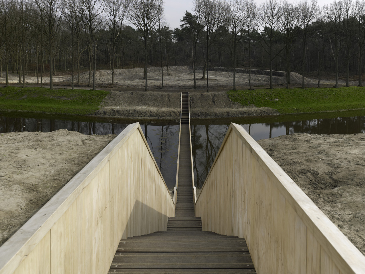
bridging the gap to Fort de Roovere, now a recreational space located in
Halsteren, The Netherlands, RO&AD Architects pursued the idea of invisibility.
The result was the picturesque Moses Bridge – a promenade that is sunken into the
West Brabant Water Line that, from a distance, achieves virtual invisiblity.
The beautifully designed structure, however, raises a few questions that I
would like to solve; namely:
:Why a sunken bridge?:How does the design account for rising water levels and rainfall?
:How does the structure fare during the harsh winters of the Netherlands?
 Through my research, I have
found that the history of the site played a large role in the development of
the “sunken bridge.” The structure crosses the West Brabant Water Line, a
moat-like area that was used by Fort de Roovere as a defensive line during the
17th century while the fort was in use. This fort, and several
others like it, suffered damage during the 19th century, but has recently
been zoned for recreational usage. When charged with the task of bridging the
gap to the fort, RO&AD Architects found that constructing a bridge across a
defensive moat to be “highly improper…especially on the side of the fortress
the enemy was expected to appear on. That’s why we designed an invisible
bridge.” The design of the bridge features a wooden pathway that is sunken into
the existing landscape. From a distance, the bridge becomes virtually invisible
as only a small sliver of the accoya wood material (a rot resistant wood that is
waterproofed with EPDM foil below the water) peeks through the surface.
Through my research, I have
found that the history of the site played a large role in the development of
the “sunken bridge.” The structure crosses the West Brabant Water Line, a
moat-like area that was used by Fort de Roovere as a defensive line during the
17th century while the fort was in use. This fort, and several
others like it, suffered damage during the 19th century, but has recently
been zoned for recreational usage. When charged with the task of bridging the
gap to the fort, RO&AD Architects found that constructing a bridge across a
defensive moat to be “highly improper…especially on the side of the fortress
the enemy was expected to appear on. That’s why we designed an invisible
bridge.” The design of the bridge features a wooden pathway that is sunken into
the existing landscape. From a distance, the bridge becomes virtually invisible
as only a small sliver of the accoya wood material (a rot resistant wood that is
waterproofed with EPDM foil below the water) peeks through the surface.

We now know that water cannot
flow over the top of the bridge element, but what about water from above? The
designers have taken into account the inevitable rainfall in the area with a practical
design solution. Each of the floor planks has an intentional gap between them
which allow rain water to permeate the walking surface (and also helps to
account for the shrinking and swelling of the material). Once the rainwater
finds its way to the space below the wooden surface, a sump pump expels the water
into the moat and the dam system takes hold to ensure that the bridge element
remains passable.

Joo Kim, Sun, ed. "RO&AD Architects: How the Moses Bridge Works." Smart Planet. SmartPlanet, 29, Jan 2012. Web. 26 Sep 2012. <http://www.smartplanet.com/blog/design-architecture/ro-ad-architects-how-the-moses-bridge-works/3838>
:Pictures courtesy of RO&AD Architects and http://www.naturalhomes.com
:Pictures courtesy of RO&AD Architects and http://www.naturalhomes.com
No comments:
Post a Comment